Climate Migration and Real Estate Forecasting
Analyzing Climate Migration Patterns
Tracking Human Movement
We know that climate change is pushing people to move. But how do we track this movement? To analyze climate migration, we need to combine different types of information. It's like being a detective, piecing together clues from various sources to understand the big picture.
The main sources of data fall into three categories:
| Data Source | What It Tells Us | Limitations |
|---|---|---|
| Census Data | Provides demographic snapshots: population size, density, and basic characteristics for specific areas over time. | Collected infrequently (e.g., every 10 years). Doesn't ask why people moved. |
| Climate Models | Project future environmental conditions like sea-level rise, temperature changes, and storm frequency. | These are projections, not certainties. Accuracy can vary by region and timescale. |
| Migration Surveys | Ask people directly about their reasons for moving, offering direct evidence of climate-related drivers. | Can be expensive and time-consuming. Often limited to small, specific populations. |
No single data source tells the whole story. The real insights come from combining them. For example, we might see a population decline in a coastal region from census data and then use climate models to see if that area is at high risk for sea-level rise. A targeted survey could then confirm if residents left because of flood risk.
Putting the Data on a Map
One of the most powerful tools for this kind of analysis is a Geographic Information System, or GIS. A GIS is a system that creates, manages, analyzes, and maps all types of data. Think of it as creating a multi-layered digital map.
You can start with a base map of a region, then add a layer showing population density from census data. On top of that, you can add another layer showing projected flood zones from a climate model. Suddenly, you can visually identify communities that are both densely populated and at high risk.
Beyond visualization, we can use statistical models to find the strength of the relationship between climate factors and migration. For instance, a model could analyze historical data to answer a question like: "For every one-foot increase in sea level, how much out-migration can we expect from this county?" These models help quantify the risk and predict potential future movements, which is critical for planning.
Learning from the Past
Analyzing past migrations provides valuable clues about how people might respond to future climate pressures. While the term "climate migration" feels modern, people have always moved in response to environmental change.
Consider the American Dust Bowl in the 1930s. A severe, prolonged drought combined with poor farming practices forced hundreds of thousands of families to leave the Great Plains. Researchers can study census records, historical climate data, and personal accounts from that era to understand who left, where they went, and what factors most influenced their decision to move.
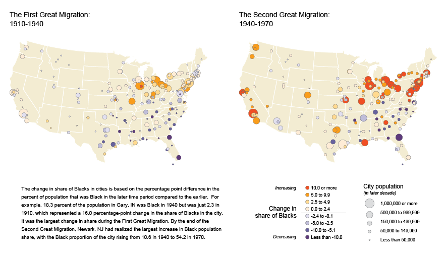
Similarly, the Great Migration of African Americans from the rural South to the urban North in the 20th century had complex economic and social drivers, but environmental factors also played a role. The boll weevil infestation, which devastated cotton crops, was a powerful environmental push factor that compounded other pressures.
By studying these historical events, we identify patterns. We learn that migration often happens in waves, not a steady trickle. We also see that people with fewer financial resources are often the most vulnerable, both to the initial climate impact and to the challenges of relocation. These lessons from the past provide a crucial foundation for understanding the migrations of the future.
Let's test your understanding of how these analytical methods work.
According to the text, why is it essential to combine different types of data (like demographic, environmental, and qualitative) to analyze climate migration?
What is the primary role of a Geographic Information System (GIS) in studying climate migration?
By combining data with powerful analytical tools, we can begin to untangle the complex story of climate migration.