The Antarctic Treaty Explained
Antarctica's Geopolitical History
The Great White Land Grab
For centuries, Antarctica was a myth, a hypothetical southern continent. Once confirmed, it quickly became the last frontier for territorial expansion. In the early 20th century, a handful of nations began staking claims on the icy landmass, sparking a quiet but intense geopolitical race.
Great Britain was first, claiming a slice in 1908. This was driven by its interests in whaling and sealing in the Southern Ocean. Other countries soon followed, each carving out a wedge-shaped piece of the continent for themselves. Norway, Australia, France, and New Zealand all made formal claims. It felt like a final act of the colonial era, with flags being planted on ice instead of inhabited lands.
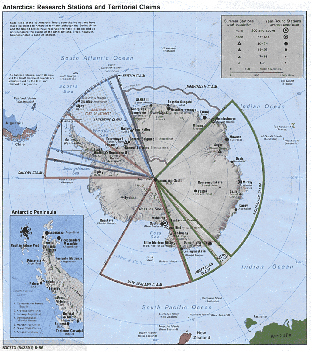
These claims weren't just lines on a map. They were assertions of sovereignty, backed by the establishment of post offices, the issuance of stamps, and even governmental appointments for these frozen territories. The motivations were a mix of national pride, securing access to potential resources like minerals and rich fishing grounds, and gaining a strategic foothold on the bottom of the world.
Overlapping Claims and Rising Tensions
The land grab inevitably led to conflict, especially on the Antarctic Peninsula. This was the most accessible part of the continent, jutting out towards South America. Great Britain, Argentina, and Chile all laid claim to the same stretch of icy, mountainous land. Their claims overlapped almost completely, creating a hot spot in the coldest place on Earth.
Argentina's claim, dating to 1942, was based on its proximity and inheritance of Spanish colonial rights. Chile's claim from 1940 was similar, citing its geographic position. Britain based its claim on early discoveries and continuous administration. The result was a messy geopolitical tangle.
These disputes weren't just diplomatic. In 1952, Argentine forces fired warning shots at a British team attempting to reestablish a base. Tensions grew, fueled by nationalism at home. The Cold War added another layer of complexity. The United States and the Soviet Union, while not making formal claims themselves, were wary of each other's activities on the continent. They reserved the right to make claims in the future and established their own scientific stations, which often doubled as strategic observation posts.
Exploration itself became a tool of geopolitics. Expeditions were no longer just for scientific discovery; they were for showing the flag and reinforcing a nation's presence. Building a permanent base, conducting research, and mapping territory were all acts that could be used to strengthen a country's legal argument for sovereignty.
Antarctica was transformed from a remote wilderness into a chessboard for international competition, where scientific outposts served as pawns.
The situation was becoming untenable. The growing number of overlapping claims and the escalating Cold War rivalries threatened to turn the continent into a zone of conflict. It became clear that a new approach was needed to manage Antarctica, one that prioritized peace and science over territorial disputes.
Now, let's test your knowledge.
Which nation was the first to formally claim territory in Antarctica in the 20th century?
The most intense territorial dispute, involving overlapping claims from three different nations, was centered on which part of Antarctica?
These brewing conflicts set the stage for one of the most remarkable achievements in international diplomacy, which would change the future of the continent.