Spatial Hydrology for Geography Students
Introduction to Spatial Hydrology
Water's Endless Journey
Water is constantly on the move. It travels from the sky to the land and back again in a continuous process called the hydrological cycle. This cycle is the engine that powers our planet's water systems, and understanding it is the first step in understanding spatial hydrology.
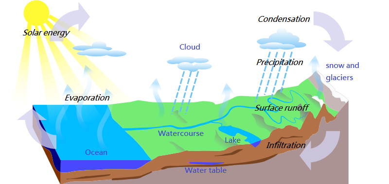
The journey begins with evaporation. The sun heats water in oceans, lakes, and rivers, turning it into vapor or steam that rises into the air. Plants also release water vapor in a process called transpiration.
As this warm, moist air rises, it cools. This causes the water vapor to turn back into tiny liquid water droplets, forming clouds. This stage is called condensation.
When enough water droplets cluster together in the clouds, they become heavy and fall back to Earth as precipitation—rain, snow, sleet, or hail. Once on the ground, the water's journey continues. Some of it soaks into the earth, becoming groundwater. The rest flows over the land as runoff, collecting in rivers, lakes, and eventually oceans, where the cycle starts all over again.
The key stages are simple: Evaporation, Condensation, Precipitation, and Collection. This cycle moves water all around the globe.
Rivers Have Borders
When rain falls, where does it go? It doesn't just flow randomly. Water is organized by the landscape into systems called watersheds. A watershed is an area of land that channels all rainfall and snowmelt to a common outlet, like a river, lake, or ocean.
Watershed
noun
An area of land where all the water that falls in it and drains off of it goes to a common outlet.
Think of a watershed as a giant funnel. The rim of the funnel is the highest point, called a divide. Any precipitation that falls inside the divide will flow down towards the center and exit at the spout. In the real world, the divide is usually a ridge of hills or mountains.
The process of identifying these boundaries is called watershed delineation. It's like drawing a line on a map that connects all the highest points around a river system. Everything inside that line is part of the watershed; everything outside it belongs to a neighboring one.
Why Water Flows Downhill
The shape of the land, or its topography, is the primary director of water flow. Gravity pulls water downwards, and topography creates the pathways for it to follow. The two main features of topography that influence water's path are slope and aspect.
Slope is the steepness of the land. Water flows faster down a steep mountainside than it does across a flat plain. This speed affects how much soil is eroded and how quickly water reaches a river. Aspect is the direction a slope faces. This can influence factors like snowmelt, with south-facing slopes in the northern hemisphere melting sooner and releasing water into the system earlier in the season.
Topography dictates not just where water flows, but also where it collects. Depressions in the landscape become ponds and lakes. Flat, low-lying areas called floodplains are where rivers naturally overflow during high water periods.
Human changes to the landscape also have a huge impact. Paving over natural ground with roads and buildings creates impervious surfaces. Water can't soak into these surfaces, so runoff increases dramatically, which can lead to flooding.
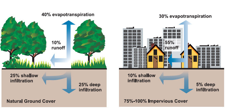
By analyzing a topographic map, we can predict water's behavior. We can see where streams will form, where flooding might occur, and how pollutants might travel through a landscape. This spatial understanding is critical for everything from city planning to environmental protection.
Now, let's test your understanding of these core concepts.
Which of the following correctly lists the primary stages of the water cycle in order, starting from water on the Earth's surface?
The boundary of a watershed, typically a ridge of hills or mountains, is called a __________.
Understanding how water moves across a landscape is fundamental. By combining the concepts of the hydrological cycle, watersheds, and topography, we can begin to see the world as a dynamic system of interconnected water pathways.