Outback Queensland Geology
Introduction to Outback Queensland Geology
An Ancient Foundation
Beneath the red soil and sparse vegetation of Outback Queensland lies a story billions of years in the making. The foundation of this landscape is a craton, an incredibly old and stable piece of the Earth's crust. Think of it as the continental basement. Much of northern and western Queensland sits on the North Australian Craton, a block of rock that has been around for over 1.8 billion years. This ancient core has provided the bedrock upon which all subsequent geological chapters have been written.
craton
noun
A large, stable block of the Earth's crust forming the nucleus of a continent.
Over hundreds of millions of years, vast inland seas rose and fell across this foundation. As mountains on the continent's edge eroded, rivers carried sand, silt, and mud westward, depositing them in layers within huge, shallow depressions called sedimentary basins. The most famous of these is the Great Artesian Basin, one of the largest underground water reservoirs in the world. It’s not an open cavern of water, but rather layers of porous sandstone saturated with water, trapped between impermeable layers of mudstone and siltstone.
These sedimentary layers, particularly from the Cretaceous period, are the source of Queensland's famous opals. The unique chemistry and slow evaporation of silica-rich water in the weathered sandstone created these precious gemstones.
Shaped by Pressure and Heat
Not all of the outback is flat sedimentary plains. In regions like the Mount Isa Inlier, the ancient basement rocks have been pushed to the surface. Here, immense heat and pressure from tectonic forces have cooked and squeezed the original rocks, transforming them into metamorphic rocks. This process, called metamorphism, folded and faulted the rock layers, creating complex structures that trapped hot, mineral-rich fluids. As these fluids cooled, they deposited valuable metals.
This geological turmoil is why the Mount Isa region is one of the world's most significant mineral provinces. It holds massive deposits of copper, lead, zinc, and silver. The intense geological activity concentrated these metals into economically viable deposits.
The combination of ancient cratons, deep sedimentary basins, and intense metamorphic events created the perfect storm for concentrating a vast array of mineral wealth.
Volcanic activity has also left its mark. While not as widespread as in other parts of Australia, ancient volcanoes have contributed to the landscape, leaving behind basalt flows and influencing the local soil composition. These volcanic rocks weather to form nutrient-rich soils, creating pockets of greater fertility in an otherwise arid environment.
Weathering the Landscape
After the mountains were built and the seas receded, a different force took over: weathering. For millions of years, wind and water have been sculpting the Queensland outback. The dramatic temperature swings between day and night cause rocks to expand and contract, creating cracks. Wind picks up sand and blasts rock surfaces, slowly wearing them away. And while infrequent, flash floods can move enormous amounts of sediment, carving channels and reshaping the plains.
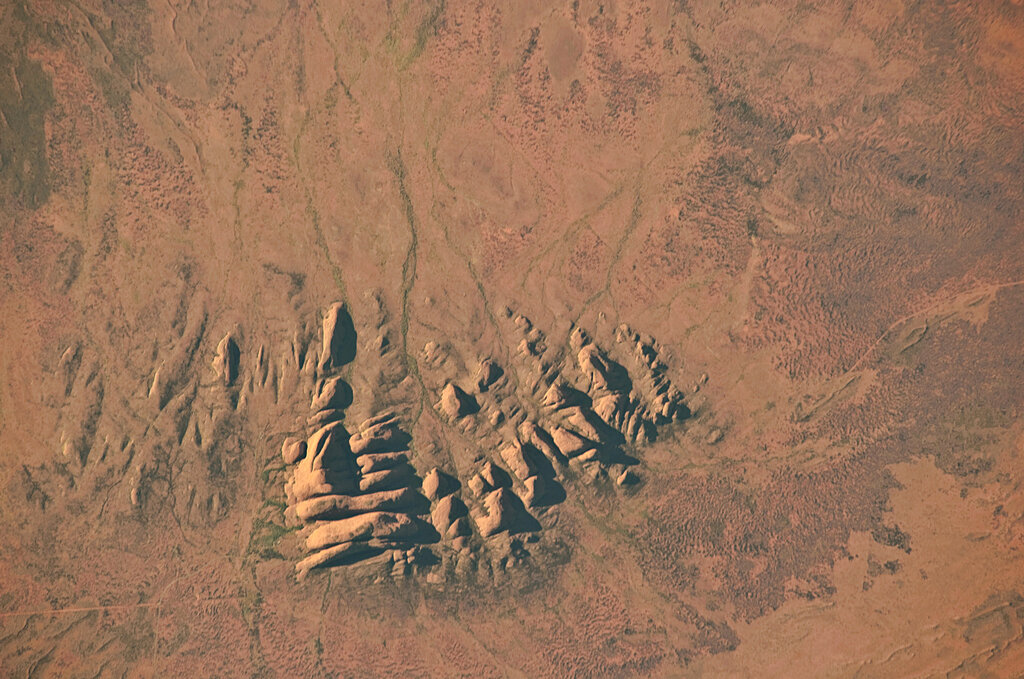
This relentless, slow-motion erosion has created the iconic landscapes we see today: flat-topped mesas, weathered rock formations, and the vast, arid plains known as the Channel Country, where a network of river channels spreads across the floodplain during rare flood events.
| Feature/Resource | Associated Geology | Key Process |
|---|---|---|
| Great Artesian Basin | Porous sandstone layers (Eromanga Basin) | Sedimentation |
| Opals | Weathered Cretaceous sandstone | Weathering & Chemistry |
| Copper, Lead, Zinc | Faulted metamorphic rocks (Mount Isa Inlier) | Metamorphism |
| Coal | Compressed plant matter in sedimentary basins | Sedimentation |
| Channel Country | Flat-lying sedimentary rock, recent river deposits | Erosion & Deposition |
Understanding these fundamental geological processes is the key to reading the landscape of Outback Queensland. Every hill, plain, and deposit of minerals is a clue to a deep and dynamic history written in stone.
What is the geological term for the ancient, stable block of Earth's crust that forms the foundation of much of Outback Queensland?
Which statement best describes the Great Artesian Basin?