Modern Urbanism and the Future of Zoning
Integrated Land-Use Systems
The Urban Organism
For much of the 20th century, urban planning operated like a filing cabinet. Planners created separate drawers for everything: a place for living, a place for working, a place for shopping. This approach, rooted in Euclidean zoning, was designed to prevent conflicts, like a factory popping up next to a school. It prized order and separation, defining city blocks by their 'use' and the empty space, or 'setbacks,' required around buildings.
The result, however, was often a disconnected landscape. By strictly separating residential, commercial, and industrial areas, this siloed system created cities that were difficult to navigate without a car. The journey from home to work to the grocery store became a series of distinct, often lengthy, trips. Modern urban planning sees this as a missed opportunity. Instead of a collection of separate parts, the contemporary view treats a city as a single, living organism. In this model, every element is part of an interdependent network, where land use is not just about what a building does, but how it interacts with everything around it.
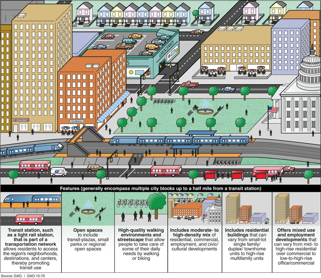
Weaving the Urban Fabric
An integrated system replaces passive regulation with active spatial strategy. It's a shift from simply drawing lines on a map to strategically choreographing the relationship between different urban systems. The most critical connection is between housing and transportation. A decision to build a new high-density apartment complex isn't just a housing decision; it's a transportation decision. It creates new demand for buses, trains, bike lanes, and sidewalks. Conversely, building a new light rail line isn't just about transport; it's a powerful tool to guide future housing and commercial development.
In an integrated system, land use planning and transportation planning are two sides of the same coin. One cannot succeed without the other.
Beyond the Property Line
Moving to an integrated system requires a more sophisticated toolkit. Simple setbacks are no longer enough. Planners now use tools like form-based codes and performance zoning. Instead of dictating a building's specific use (e.g., 'retail only'), these codes regulate its physical form and its relationship to the public space. How close is it to the sidewalk? Does it have windows facing the street? Is there a public plaza out front? The goal is to shape a high-quality urban experience, regardless of whether the building houses an office, apartments, or a cafe.
This evolution of urban geometry demands a new level of teamwork. Effective integration is impossible without . This means city planners, transportation engineers, housing authorities, private developers, environmental agencies, and community groups must all work together from the very beginning. A developer's plan for a new mixed-use project has to align with the transit agency's 10-year bus route expansion and the parks department's greenway initiative. It's a complex, continuous conversation, but it's essential for creating cities that are more than just a collection of zones. They become cohesive, resilient, and livable systems.
Time to check your understanding of these advanced planning concepts.
What is the primary characteristic of Euclidean zoning?
According to the modern view, a decision to build a new high-density apartment complex is also considered a decision about what?
By shifting from rigid separation to strategic integration, urban planning helps shape cities that are efficient, equitable, and adaptable to the needs of the future.