Middle School Weather Systems Science
Atmospheric Pressure Dynamics
Why Air Moves
The engine of all weather is the sun, but its energy isn't distributed evenly. The equator gets blasted with direct sunlight, while the poles receive slanted, weaker rays. This simple fact creates a planet-wide temperature imbalance. Air over the warm equator heats up, expands, becomes less dense, and rises. At the cold poles, the air cools, contracts, becomes denser, and sinks. This fundamental vertical movement of air is the first step in creating wind and weather systems. It’s a constant global shuffling match, with warm air trying to move poleward and cold air trying to slide toward the equator.
Ultimately, all wind is just air flowing from an area of higher pressure to an area of lower pressure, trying to balance things out.
Pressure Systems Explained
When a large mass of air warms and rises, it leaves behind a region with less air pressing down on the surface. This is a low-pressure system. As that air ascends into the upper atmosphere where the pressure is lower, it expands. This expansion uses energy, causing the air to cool without any loss of heat to its surroundings. This process is called adiabatic cooling, and it's the primary driver of cloud formation. As the air cools, its water vapor condenses into tiny droplets, forming clouds and eventually precipitation. At the surface, air rushes inward toward the center of the low to fill the void, a process called convergence.
Conversely, a high-pressure system forms where cool, dense air sinks. As the column of air descends, it gets compressed by the increasing pressure closer to the ground. This compression heats the air, a process known as adiabatic heating. Warmer air can hold more moisture, so this process tends to evaporate any existing cloud droplets, leading to clear, sunny skies. At the surface, the sinking air has to go somewhere, so it flows outward, away from the center of the high. This is called divergence.
If the Earth didn't rotate, wind would simply flow in a straight line from high to low pressure. But our planet's spin introduces a twist: the . This apparent force deflects moving objects, including vast masses of air, to the right in the Northern Hemisphere and to the left in the Southern Hemisphere. It doesn't create wind, but it dictates its path.
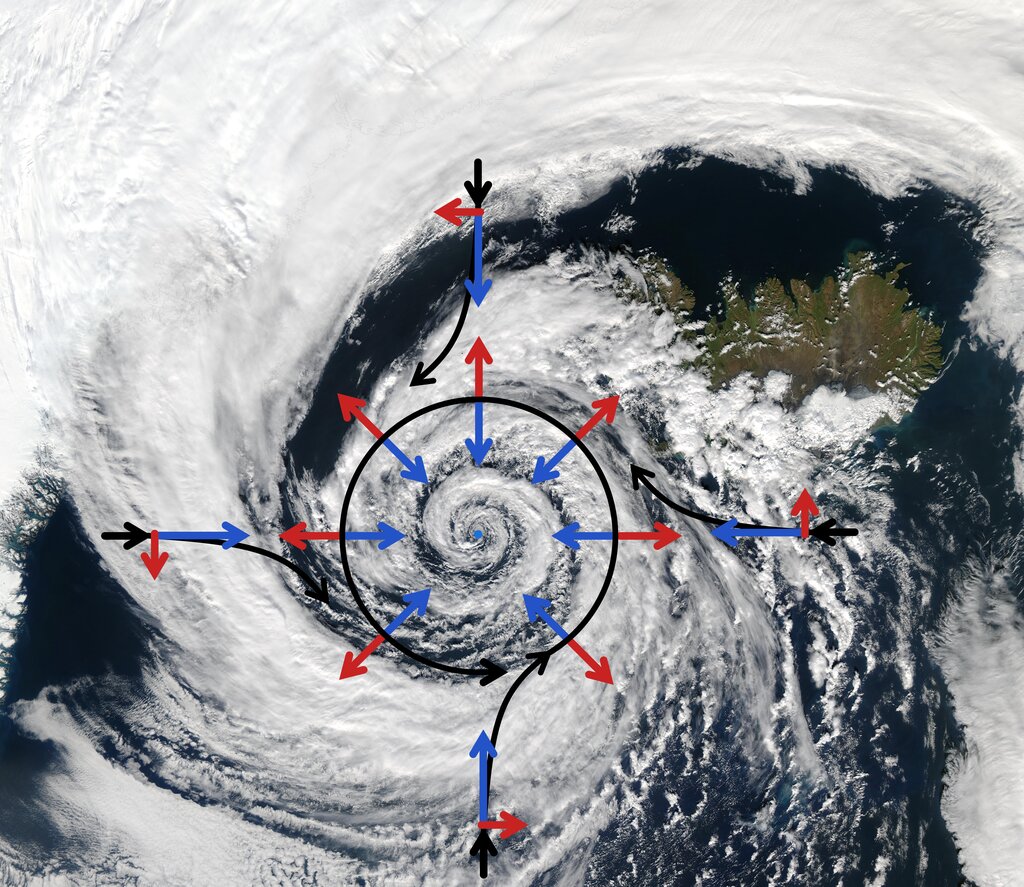
Because of this deflection, air doesn't flow directly into a low-pressure center. Instead, it spirals inward in a counter-clockwise direction in the Northern Hemisphere. This is called cyclonic flow. Around a high-pressure center, the outward-flowing air is also deflected to the right, creating a clockwise spiral. This is known as anticyclonic flow.
The Bermuda High in Action
A perfect real-world example of these principles is the a semi-permanent high-pressure system that lives over the Atlantic Ocean. Its strength and position dictate much of the summer weather for the Southeastern United States. Because it is a high-pressure system, winds flow out from it in a clockwise (anticyclonic) direction.
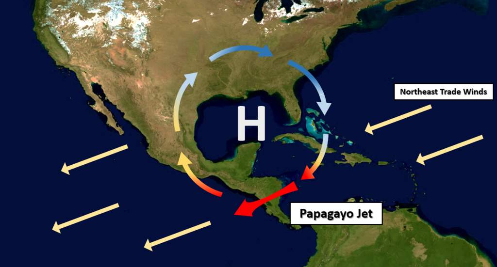
This clockwise flow acts like a giant paddlewheel. It scoops up warm, incredibly humid air from the Gulf of Mexico and the tropical Atlantic and funnels it directly into states like Georgia. This is the source of the region's famously hot and sticky summers. When the Bermuda High is particularly strong and parks itself directly over the Southeast, the sinking air within the high suppresses cloud formation and rain, leading to prolonged heat waves and potential drought conditions. Its position is one of the first things meteorologists in the region check each day.
Understanding these large-scale pressure dynamics is the key to understanding why our daily weather behaves the way it does. It's not random; it's a direct result of the interplay between solar heating, air density, and the spin of our planet.