Meteorological Data and Current Weather Analysis
Atmospheric Pressure Dynamics
The Engine of Weather
Air might seem weightless, but it has mass. The weight of the column of air above any given point exerts a force on the surface below. We call this atmospheric pressure. Crucially, this pressure isn't uniform across the globe. These differences in pressure, or pressure gradients, are the fundamental driver of wind and weather.
Fluids, including air, always move from an area of higher pressure to an area of lower pressure. This movement is what we feel as wind.
We can think about these gradients in two directions. A horizontal pressure gradient exists when pressure differs across a horizontal distance, like between a city experiencing fair weather (high pressure) and one bracing for a storm (low pressure). The steeper this gradient—meaning the greater the pressure difference over a shorter distance—the faster the wind blows.
Vertically, pressure always decreases with altitude. This creates a strong upward-pointing pressure gradient force. So why doesn't all the air just rush off into space? Gravity pulls it back down. When these two forces are in balance, the atmosphere is in a state of . This balance explains why the atmosphere generally remains stable and layered, rather than flying apart.
The Planet's Spin
If air simply flowed directly from high to low pressure, weather patterns would be straightforward. But the Earth's rotation adds a crucial twist. This is the , an apparent force that deflects moving objects, including vast air masses. In the Northern Hemisphere, this deflection is to the right of the direction of motion; in the Southern Hemisphere, it's to the left.
As air starts moving due to the pressure gradient force (PGF), the Coriolis force begins to act on it, pulling it sideways. Eventually, at higher altitudes where friction with the ground is negligible, these two forces can fall into a perfect balance. The PGF pushes the air towards the low-pressure zone, while the Coriolis force pulls it at a right angle. The result is wind that blows parallel to the lines of equal pressure, not across them. This balanced wind is known as the geostrophic wind.
Reading the Weather Map
Meteorologists use synoptic charts, or surface pressure maps, to visualise these dynamics. These maps are covered in lines called , which connect points of equal atmospheric pressure. Where the isobars are packed closely together, the pressure gradient is steep, and winds are strong. Where they are far apart, the gradient is gentle, and winds are light.
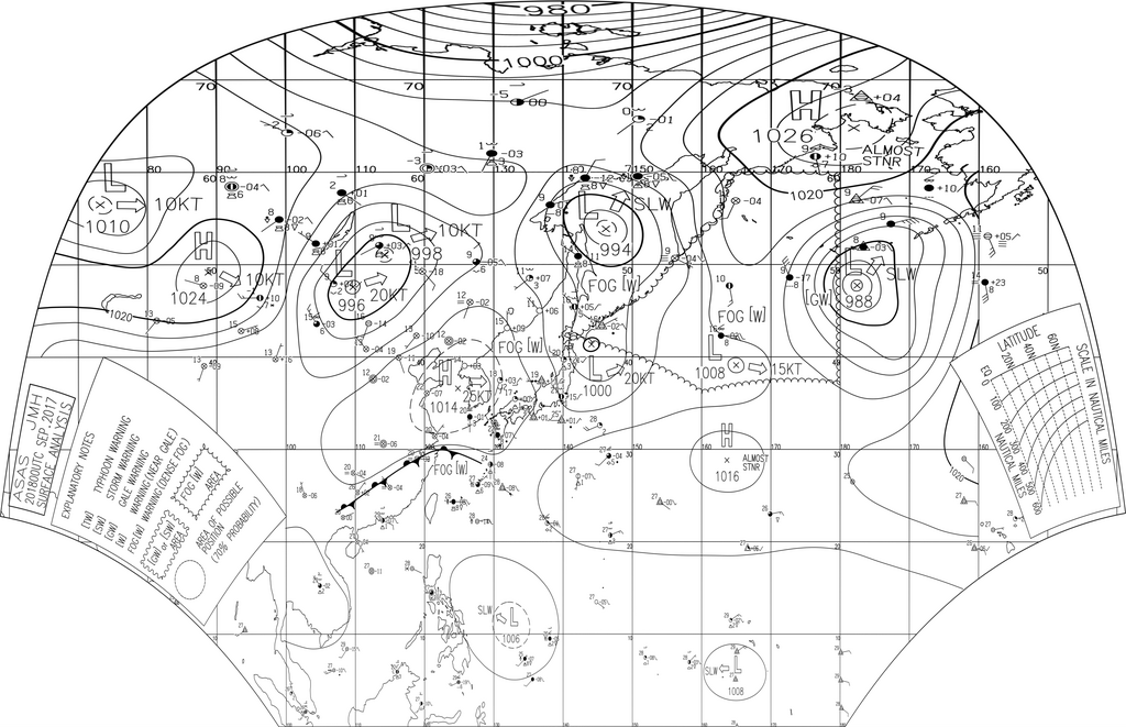
At the centre of these patterns are high and low-pressure systems. Low-pressure systems, known as cyclones, are areas where air is rising. Due to the Coriolis effect, surface winds spiral inwards and counter-clockwise towards the centre of a low in the Northern Hemisphere. This rising, converging air cools and often leads to cloud formation and precipitation.
High-pressure systems, or anticyclones, are the opposite. Air sinks towards the surface and spirals outwards in a clockwise direction in the Northern Hemisphere. Sinking air warms and dries out, so high-pressure systems are typically associated with clear skies and calm weather.
| Feature | Low Pressure (Cyclone) | High Pressure (Anticyclone) |
|---|---|---|
| Air Movement | Rising / Converging | Sinking / Diverging |
| N. Hemisphere Spin | Counter-clockwise | Clockwise |
| Associated Weather | Clouds, precipitation, storms | Clear skies, calm conditions |
By analysing the location of these systems and the pattern of isobars on a synoptic chart, you can make a solid prediction about wind direction and speed for any given location.
Now, let's test your understanding of how these pressure dynamics work together to create weather.
What is the primary cause of wind on Earth?
On a weather map, what do closely packed isobars indicate?
Understanding these fundamental forces is the key to decoding weather maps and anticipating how the atmosphere will behave.