Mastering Urban Morphology Methods
Historical Geographical Method
Reading the City's Blueprint
A city isn't just a collection of buildings and roads; it's a living document, a text written over centuries. To read this text, urban morphologists use a method of analysis that breaks the city down into its fundamental components. This approach, pioneered by , treats the town plan as a historical artifact that can be systematically deconstructed.
The analysis starts with three core elements:
- The Street System: The network of public spaces that provides access and enables movement. The layout of streets is often the most permanent feature of a city's plan.
- The Plot Pattern: The arrangement of individual land parcels or properties. These are the basic units of land ownership upon which buildings are constructed.
- The Building Fabric: The three-dimensional structures that occupy the plots. Buildings are often the most transient element, being altered or replaced over time.
Conzen’s approach emphasizes historical analysis, breaking urban form into three components: town plan, building fabric, and land utilization.
These three elements are deeply interconnected. The street layout determines the shape and size of the plots, which in turn constrain the form and placement of the buildings. By analysing each element separately and then together, we can start to understand the forces that shaped a particular urban area.
Uncovering Morphological Periods
As you walk through a city, you can often sense when you've passed from an older district into a newer one. The streets might narrow, the buildings might change style, and the whole feel of the place shifts. These distinct areas are what morphologists call plan units. Each plan unit has a consistent character defined by its unique combination of street, plot, and building patterns, reflecting the time it was developed.
To identify these units and the historical eras they belong to, geographers use a technique called . This involves layering historical maps from different time periods on top of one another. Modern Historical Geographic Information Systems (HGIS) are essential for this work. By georeferencing old maps—pinning them to modern coordinates—we can precisely overlay them and trace how the city's fabric has evolved.
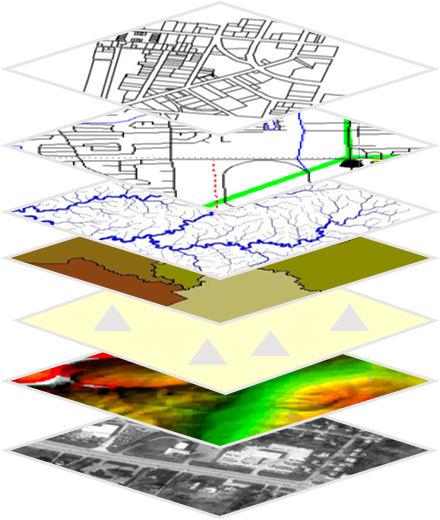
This layering process reveals distinct morphological periods. For example, a medieval core with its irregular streets and narrow plots might be surrounded by a Georgian expansion with a rigid grid plan and uniform terraces. Further out, a Victorian suburb of semi-detached houses could represent another period. Each layer tells a story of the economic, social, and technological conditions of its time.
Growth Rings of the City
Cities don't always grow steadily. They experience periods of rapid expansion followed by times of stagnation. The physical evidence of these cycles is often found in what Conzen termed the fringe belt. Think of it like the growth rings of a tree.
A fringe belt forms at the edge of the built-up area during a period of slow growth or standstill. Because land here is cheaper and less constrained, it attracts land uses that require large plots: hospitals, cemeteries, railway yards, large parks, and university campuses. When the city later expands beyond this belt, this zone of distinctive land uses becomes embedded within the urban fabric, a permanent marker of a former city edge.
By identifying a series of fringe belts, we can map the city's historical expansion in distinct pulses of growth and pause.
Measuring the Past
The analysis can get even more detailed. By digitising specific plot series within a plan unit, we can perform a metrological analysis. This involves measuring the dimensions of historic plots, particularly their frontage (width along the street) and depth. Often, plots laid out in a specific historical period will have highly regular dimensions, sometimes based on traditional units of measurement like the rod or perch.
Finding this regularity can confirm that a group of plots were all laid out at the same time as part of a planned development. Conversely, a jumble of irregular plot sizes might suggest more organic, piecemeal growth. This technique is especially powerful for identifying the original medieval or post-medieval cores of towns, where these planned plot series, known as , can survive for centuries, even when the buildings on them have been replaced many times over.
This detailed, evidence-based approach moves us beyond simply describing a city's appearance. It allows us to identify the underlying structural logic of a place, to understand how its present form is a product of specific historical processes, and to appreciate the resilience of the town plan itself.
According to the Conzenian school of urban morphology, what are the three fundamental elements that constitute a town plan?
In urban morphology, what is a 'fringe belt'?