Leaflet Mapping Essentials
Introduction to Leaflet.js
Your First Look at Leaflet.js
If you've ever seen an interactive map on a website, there's a good chance you were looking at Leaflet.js in action. Leaflet is a popular open-source JavaScript library for creating mobile-friendly, interactive maps. Think of it as a toolbox that gives web developers everything they need to add a dynamic map to a webpage, without the heavy lifting.
Its main appeal is its simplicity and performance. It was designed to be small, fast, and easy to use, focusing on just the essential features that most developers need. This lean approach makes it a favorite for projects where speed and efficiency are important.
A Brief History
Leaflet was created in 2011 by Volodymyr Agafonkin, a Ukrainian developer. At the time, online mapping libraries were often large, slow, and complicated. Agafonkin wanted to build something different: a library that was lightweight, straightforward, and focused on a great user experience.
The goal was to provide developers with a powerful yet simple tool for map visualization. This philosophy of "simplicity, performance, and usability" has guided its development ever since, helping it become one of the most widely used mapping libraries on the web.
Core Features
Leaflet packs a lot of power into a small package. It handles the fundamental tasks of online mapping with ease. Here are some of its core capabilities:
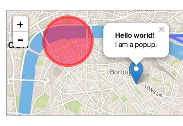
Tile Layers: Interactive maps are typically made of many small square images, or "tiles," stitched together. Leaflet excels at fetching and displaying these tiles from various sources, forming a seamless, zoomable map.
Markers: You can easily place customizable markers on the map to pinpoint specific locations, like a store, a landmark, or a user's current position.
Popups & Tooltips: Attach small bubbles of information (popups) or labels (tooltips) to your markers or shapes to provide context when a user interacts with them.
Vector Layers: Beyond markers, you can draw shapes directly on the map. This includes lines (for routes), circles (for areas of interest), and polygons (for defining boundaries).
Leaflet also has excellent support for GeoJSON, a standard format for representing geographic features. This makes it incredibly easy to take data from almost any source and plot it on your map.
How Leaflet Stacks Up
Leaflet isn't the only mapping library out there. Developers can also choose from tools like the Google Maps API or OpenLayers. Each has its strengths, but Leaflet occupies a sweet spot for many projects.
Unlike the Google Maps API, which is a proprietary product with usage limits and costs, Leaflet is completely open-source and free. Compared to OpenLayers, which is an incredibly powerful and feature-rich library, Leaflet is much smaller and easier to learn. It prioritizes simplicity over having every feature imaginable.
| Feature | Leaflet.js | Google Maps API | OpenLayers |
|---|---|---|---|
| Size | Lightweight (~42 KB) | Heavier | Heavyweight |
| License | Open-Source (BSD) | Proprietary | Open-Source (BSD) |
| Ease of Use | Very easy | Moderate | Complex |
| Core Focus | Simplicity, performance | Full suite of services | Power, flexibility |
This focus makes Leaflet an ideal choice for projects that need a fast, reliable map without the complexity or cost of larger platforms.
A Thriving Ecosystem
One of Leaflet's greatest strengths is its community. Because it's open-source, a vast ecosystem of plugins has been built around its core library. Need to display a heatmap, animate a marker along a path, or add data from a specific provider? There's probably a plugin for that.
This extensive plugin library means you can start with a simple, lightweight map and add more advanced functionality as your project requires. The active community also provides excellent support through forums, tutorials, and documentation, making it easy to get help when you need it.
What is Leaflet.js primarily used for?
Which phrase best describes the core philosophy behind Leaflet's design?