Decoding Weather Maps
Introduction to Meteorology
The Air Around Us
Weather is what happens in the atmosphere, the blanket of gases surrounding our planet. It’s a dynamic, swirling mix that protects us from the harshness of space and creates the conditions for life. While it feels like just 'air,' it's actually a specific blend of different gases.
| Gas | Percentage by Volume |
|---|---|
| Nitrogen (N₂) | 78.08% |
| Oxygen (O₂) | 20.95% |
| Argon (Ar) | 0.93% |
| Trace Gases (CO₂, Neon, etc.) | < 0.04% |
| Water Vapor (H₂O) | 0-4% (variable) |
This mixture isn't uniform from the ground up. The atmosphere is layered, like an onion, and each layer has its own distinct characteristics. Nearly all the weather we experience—from gentle breezes to powerful hurricanes—happens in the lowest layer.
The layer we live in is the troposphere. It’s where clouds form, rain falls, and winds blow. Above that is the stratosphere, which contains the ozone layer that absorbs harmful ultraviolet (UV) radiation. Next are the mesosphere, where most meteors burn up, and the thermosphere, the edge of our atmosphere where space begins.
The Sun's Power
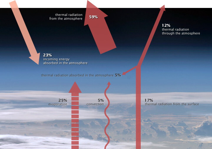
The sun is the engine that drives Earth’s weather. It bombards our planet with energy in the form of solar radiation. The atmosphere and the surface absorb some of this energy, and reflect the rest back into space. For Earth's temperature to remain stable over the long term, the incoming energy and outgoing energy must be balanced.
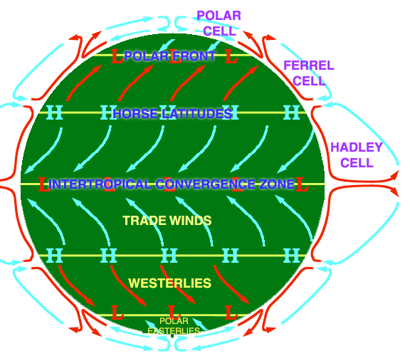
Because the Earth is a sphere, the sun's rays hit it most directly at the equator, making it warmer than the poles. This temperature difference is crucial. Nature is always trying to find balance, so it moves warm air from the tropics toward the poles and cold air from the poles toward the tropics. This movement is the foundation of global wind patterns and atmospheric circulation.
Traveling Pockets of Air
As air sits over a particular region, like a warm ocean or a frozen tundra, it takes on the characteristics of that surface. A huge body of air with relatively uniform temperature and humidity is called an air mass.
Think of an air mass as a huge bubble of air that takes on the personality of the surface it’s sitting over.
Meteorologists classify air masses based on where they form (their source region). The name tells you its story: 'maritime' means it formed over water and is moist, while 'continental' means it formed over land and is dry. 'Tropical' means it’s warm, 'polar' means it's cold, and 'arctic' means it’s extremely cold.
| Air Mass Type | Name | Source Region | Characteristics |
|---|---|---|---|
| cP | Continental Polar | Cold landmasses | Cold and dry |
| cA | Continental Arctic | Arctic regions | Extremely cold and dry |
| cT | Continental Tropical | Hot deserts | Hot and dry |
| mP | Maritime Polar | Cold oceans | Cool and moist |
| mT | Maritime Tropical | Warm oceans | Warm and moist |
When Air Masses Collide
Weather gets interesting when these giant air masses move and bump into each other. The boundary between two different air masses is called a front. Since the air masses have different densities—warm air is less dense than cold air—they don’t mix easily. Instead, the warmer air is forced to rise over the colder air. This upward movement is a key ingredient for making clouds and causing precipitation.
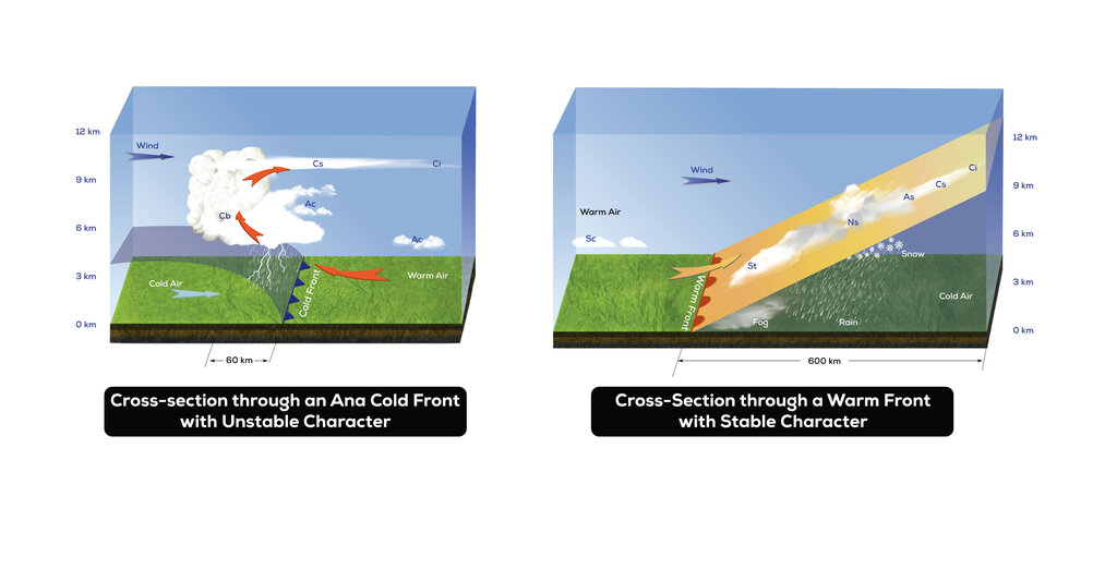
There are two main types of fronts, named for the type of air that is advancing.
Cold Front: When a cold air mass pushes into a warmer air mass, it forces the warm air to rise rapidly. This can create dramatic, towering clouds (cumulonimbus) and lead to short but intense periods of rain or thunderstorms.
Warm Front: When a warm air mass slides up and over a colder air mass, the lifting is much more gradual. This typically produces widespread, layered clouds (stratus) and gentle, prolonged precipitation.
Understanding these basic building blocks—the atmosphere, solar energy, air masses, and fronts—is the first step to understanding the complex and fascinating world of weather.
In which layer of the atmosphere does nearly all of Earth's weather occur?
What is the primary driver of Earth's weather and global wind patterns?