CLIMADA Flood Risk Presentation
Introduction to Flood Risk Assessment
Understanding Flood Risk
When heavy rains start, some people wonder, "Will my home flood?" But that's only part of the question. A better question is, "What's my flood risk?" Risk isn't just about the chance of something bad happening. It's also about how bad the consequences could be if it does.
Flood risk assessment is the process of figuring this out. It's a systematic way to look at where floods might happen, what's in their path, and how much damage they could cause. Think of it as a detective story where the clues are weather patterns, maps, and community structures. The goal is to understand the potential threat before the water starts to rise.
Flood risk assessment helps us move from simply reacting to floods to proactively preparing for them.
The Three Pieces of the Puzzle
To understand flood risk, we need to look at three key components: hazard, exposure, and vulnerability. If you're missing any one of these, you don't have risk. They all have to be present for a threat to exist.
Let's break down each piece.
Hazard
noun
The flood event itself. It's the physical phenomenon of water covering an area that is usually dry.
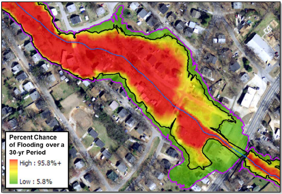
A hazard assessment looks at how likely a flood is and what it might look like. Experts study historical flood records, analyse rainfall data, and map the local terrain (topography). They ask questions like:
- How often might a flood of a certain size happen here? (e.g., a "1-in-100-year flood")
- How deep will the water get?
- How fast will it be moving?
Exposure
noun
The people, property, infrastructure, and economic activities located in a flood-prone area.
Exposure analysis is essentially about taking inventory. If a flood happens in a particular valley, what's in the water's path? Analysts use maps, satellite imagery, and census data to identify everything that could get wet: houses, schools, roads, farms, power lines, and, most importantly, people.
Vulnerability
noun
The characteristics that make people or assets susceptible to the damaging effects of a hazard.
Just because something is exposed doesn't mean it will be destroyed. Vulnerability describes how well it can withstand the flood. For example, a concrete bridge is far less vulnerable than a small wooden footbridge. A community with a well-practised evacuation plan and early warning system is less vulnerable than one without.
Vulnerability assessment considers factors like building construction, the age and mobility of the population, economic stability, and the effectiveness of local warning systems.
A Tool for Better Planning
So, why do all this work? Flood risk assessment isn't just an academic exercise. It's a crucial tool for disaster risk management and smart urban planning.
By understanding the specific risks a community faces, planners and emergency managers can make better decisions. They can use the information to:
- Develop effective evacuation routes and emergency plans.
- Create building codes that require flood-resistant construction in high-risk areas.
- Decide where to build (or not build) critical infrastructure like hospitals and schools.
- Plan the location of flood defences like levees or floodwalls.
By combining the knowledge of hazards, exposure, and vulnerability, a community can see its unique flood risk profile. This understanding is the first and most important step in building a safer, more resilient future.
Which of the following are the three essential components that must all be present to constitute a flood risk?
An expert studies historical records and local terrain to determine that a particular valley is likely to experience a flood with fast-moving water up to 2 metres deep once every 50 years. What is this process called?