AI Integration for Geospatial Developers
Introduction to Geospatial AI
Giving AI a Sense of Place
Artificial intelligence is great at finding patterns, but for a long time, it lacked a sense of direction. It could analyze what was happening, but not necessarily where it was happening. That’s where Geospatial AI, or GeoAI, comes in. It's the fusion of AI methods with geographic data.
Think of it this way: a standard AI might analyze thousands of customer reviews to spot a trend in complaints. A GeoAI system does the same, but it can also pinpoint that the complaints are all coming from a specific neighborhood, or along a single delivery route. It adds a crucial layer of context to the data.
GeoAI stands at the intersection of geographic information science and artificial intelligence.
This isn't just about putting dots on a map. GeoAI aims to understand the complex relationships between locations. It analyzes spatial patterns and temporal trends to make predictions and uncover insights that would be invisible otherwise.
Key Ingredients
A GeoAI system is built on a few core components working together. It starts with the data, then uses AI to process it with spatial awareness.
-
Geospatial Data: This is the raw material. It can be anything with a location tag, from satellite images and drone footage to GPS coordinates, weather data, and even geotagged social media posts. This data provides the rich, location-based context.
-
AI Models: These are the engines that learn from the data. Techniques like machine learning and deep learning are trained to recognize patterns, classify objects, and make predictions. For example, an AI model could be trained on satellite images to automatically identify new building construction or deforestation.
-
Spatial Analysis: This is the specialized geographic logic. It goes beyond simple analysis by incorporating concepts like proximity, density, and connectivity. It helps the system understand that a hospital located next to a highway is more accessible than one on a remote island, a fact that pure data analysis might miss.
When these components work together, they can produce powerful, location-aware intelligence.
Why It Matters
Integrating AI with geospatial data isn't just a technical exercise; it solves real-world problems and creates new opportunities across many fields. The ability to process vast amounts of geographic information quickly and accurately is transformative.
GeoAI helps us see, understand, and act on the spatial dimension of our world in ways that were previously impossible.
Consider these examples:
-
Urban Planning: Cities can analyze traffic patterns to optimize public transportation routes, or use satellite imagery to monitor urban sprawl and plan for green spaces.
-
Environmental Monitoring: Scientists can track deforestation, monitor the health of coral reefs, or predict the path of wildfires by analyzing satellite data over time. This allows for faster responses to environmental threats.
-
Disaster Response: During a flood, GeoAI can rapidly analyze aerial images to identify passable roads, locate stranded individuals, and map the extent of the damage, helping emergency crews direct resources more effectively.
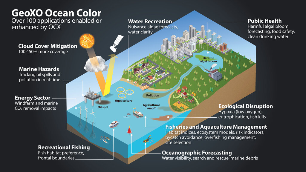
The benefits extend to agriculture, logistics, public health, and retail. By understanding the 'where,' organizations can make smarter, more efficient, and more impactful decisions.
The Challenges Ahead
Despite its promise, implementing GeoAI isn't always straightforward. Several hurdles can complicate the process.
First, data quality and availability are significant concerns. Geospatial data can be messy, incomplete, or come in various formats. Cleaning and standardizing this data is a major undertaking. An AI model is only as good as the data it's trained on, and poor-quality spatial data can lead to flawed conclusions.
Next, interoperability can be a problem. Different geospatial systems and tools don't always speak the same language. Getting data to flow smoothly between a Geographic Information System (GIS), a data storage platform, and an AI model requires careful engineering.
Finally, there's a need for domain-specific models. A model designed to analyze urban landscapes won't be effective for agricultural monitoring without significant adaptation. Building and training AI models that understand the specific nuances of a particular geographic context takes time, expertise, and a lot of relevant data.
Overcoming these challenges is key to unlocking the full potential of GeoAI. It requires a combination of good data practices, smart system design, and deep subject-matter expertise.
Understanding these foundations is the first step toward appreciating how AI is being woven into the fabric of modern geospatial software.
Time for a quick check on what we've covered.
What is the primary function of Geospatial AI (GeoAI)?
Which of the following are all considered core components of a GeoAI system as described in the text?
Now you have a solid grasp of what GeoAI is, what it's made of, and the challenges involved in making it work.