Advanced Satellite Navigation Systems
Orbital Dynamics and Geometry
Orbits by Design
Global Navigation Satellite System (GNSS) constellations are not random assortments of satellites. They are meticulously designed orbital patterns, engineered to provide continuous global coverage. Most major systems, including GPS and GLONASS, place their satellites in Medium Earth Orbit (MEO), a region roughly 20,000 km above the Earth's surface. At this altitude, satellites complete an orbit in about 12 hours, ensuring they pass over any given point twice a day.
Each constellation uses a unique configuration to achieve its goals. The American GPS system arranges its satellites in six orbital planes, each tilted at an inclination of 55 degrees relative to the equator. This provides robust coverage across most of the populated world.
Russia's GLONASS system takes a different approach, using just three orbital planes but with a higher inclination of 64.8 degrees. This steeper angle gives GLONASS an advantage in providing reliable service to polar regions, a crucial consideration for northern latitudes.
Europe's Galileo system employs a highly optimized pattern known as a constellation. This configuration uses three orbital planes inclined at 56 degrees. The specific spacing of satellites within these planes is designed to maximise coverage and minimise the number of satellites required, offering high availability and redundancy worldwide.
The Language of Orbits
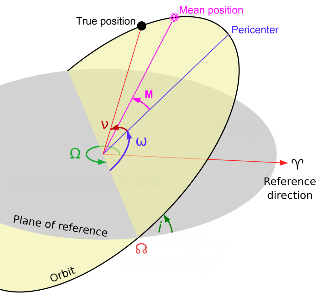
To describe these complex paths, we use a set of six parameters called or orbital elements. These values precisely define the shape, size, and orientation of an orbit in space, as well as the satellite's position within that orbit.
Here’s a quick breakdown:
- Eccentricity (): Defines the shape of the ellipse. For most GNSS satellites, orbits are nearly circular, with eccentricities very close to zero.
- Semi-major Axis (): Determines the size of the orbit, representing half of the longest diameter of the ellipse.
- Inclination (): The angle of the orbital plane relative to the Earth's equatorial plane. As we saw with GLONASS, a higher inclination improves visibility at higher latitudes.
- Right Ascension of the Ascending Node (): Orients the orbital plane in 3D space. It measures the angle from a fixed reference direction (the vernal equinox) to the point where the satellite crosses the equator moving north.
- Argument of Perigee (): Defines the orientation of the ellipse within its orbital plane. It's the angle from the ascending node to the orbit's point of closest approach to Earth (perigee).
- True Anomaly (): Specifies the satellite's exact position along its elliptical path at a specific time.
Predicting Positions
Your GNSS receiver doesn't just listen for signals; it actively downloads data that tells it where each satellite is supposed to be. This information comes in two forms: the almanac and the ephemeris.
The almanac is a general-purpose dataset containing coarse orbital information for all satellites in a constellation. Think of it like a bus schedule for the entire system. It's valid for several weeks and helps your receiver quickly figure out which satellites should be visible in the sky at any given moment. This allows for a faster initial signal acquisition.
The data is far more precise. It provides the detailed Keplerian elements for a single satellite, allowing your receiver to calculate its exact position in space down to the centimetre. This data is only valid for a few hours because satellite orbits are constantly disturbed by factors like the Earth's non-uniform gravity, atmospheric drag, and solar radiation pressure. Each satellite broadcasts its own ephemeris data, which is updated regularly by ground control stations.
| Data Type | Purpose | Precision | Validity |
|---|---|---|---|
| Almanac | Quick satellite acquisition | Low (kilometres) | Several weeks |
| Ephemeris | Precise position calculation | High (centimetres) | A few hours |
The Geometry of Accuracy
Even with perfect timing signals, the accuracy of your position depends heavily on the geometry of the visible satellites. This concept is quantified by a value called Geometric Dilution of Precision, or GDOP.
Imagine trying to pinpoint a location using lines from three points. If those points are spread far apart, their lines intersect at a sharp, well-defined point. If the points are clustered close together, their lines intersect at a shallow angle, creating a large area of uncertainty. The same principle applies to GNSS.
When satellites are widely spaced across the sky, the GDOP value is low, and your calculated position is highly accurate. When the visible satellites are bunched together in one part of the sky, the GDOP is high, and the accuracy degrades. This often happens in urban canyons or mountainous terrain where the view of the sky is obstructed.
GDOP is a single number that combines the uncertainty in three dimensions (latitude, longitude, altitude) plus time. We often break it down into components:
- HDOP: Horizontal Dilution of Precision (latitude, longitude)
- VDOP: Vertical Dilution of Precision (altitude)
- TDOP: Time Dilution of Precision (receiver clock offset)
Mathematically, the relationship is:
For a receiver to provide a reliable position, it needs at least four satellites with good geometry (a low GDOP value). The ability to track satellites from multiple constellations like GPS, GLONASS, and Galileo simultaneously means a receiver is more likely to find a sufficient number of well-spaced satellites, dramatically improving accuracy and reliability, especially in challenging environments. This multi-constellation integration is the key to modern high-precision positioning.
What is the primary advantage of the GLONASS constellation's high orbital inclination of 64.8 degrees?
A hiker in a deep, narrow canyon is struggling to get an accurate GPS fix. This is most likely due to a:
The design of these orbits and the mathematics that govern them are fundamental to how we navigate our world.