Advanced Aviation TAF Analysis
Advanced Forecasting Principles
Reading Between the Lines of a TAF
A Terminal Aerodrome Forecast (TAF) is more than a simple weather report. It's a story about the atmosphere, written in a specialized code. To truly understand it, especially when conditions are complex, you need to grasp the large-scale atmospheric forces at play. These forces are the drivers behind the visibility, cloud cover, and wind changes detailed in any forecast.
Think of it like being a detective. The TAF provides clues, but understanding the criminal's motives—in this case, the behavior of the atmosphere—lets you anticipate their next move. We'll explore some of these major atmospheric players, starting with the boundaries where different air masses collide.
When Air Masses Meet
The atmosphere is not a uniform soup. It's a collection of distinct air masses, each with its own temperature and moisture characteristics. Where these air masses meet, they don't mix easily. Instead, they form a boundary called a front. The type of front depends on which air mass is advancing.
Frontal systems are a primary source of significant weather changes, from cloud formation and precipitation to shifts in wind and temperature. Their movement is a key factor in forecasting.
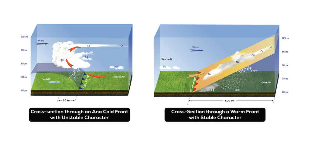
A cold front occurs when a colder, denser air mass pushes into a warmer one. Because the cold air is heavy, it wedges underneath the warm air, forcing it to rise rapidly. This rapid uplift creates vertically developed clouds, like cumulonimbus. For pilots, this means the potential for thunderstorms, heavy rain, turbulence, and a sharp wind shift as the front passes. Visibility might be poor in precipitation but improves quickly behind the front.
A warm front is the opposite. A warmer, lighter air mass slides up and over a colder, denser one. This creates a much more gradual slope. The result is widespread, layered cloud cover (stratus clouds) and steady, light to moderate precipitation that can last for hours. Fog is also common ahead of a warm front, leading to prolonged periods of low ceilings and poor visibility (IFR conditions).
An occluded front forms when a fast-moving cold front overtakes a warm front, lifting the warm air entirely off the ground. This process combines the weather from both front types, often resulting in complex and severe conditions. Finally, a stationary front is a boundary that isn't moving. Weather along a stationary front is similar to a warm front but can persist in one area for days, causing extended periods of clouds and precipitation.