Python for Geodata Analysis
Geospatial Data Fundamentals
The Language of Location
Geospatial data is information with a geographic aspect. It's data that knows where it is in the world. Think about the app that shows you the nearest coffee shop or a weather map displaying rainfall. Both rely on geospatial data to connect information to a specific place on Earth.
This data comes in two main flavors: vector and raster. Understanding the difference is the first step in learning to speak the language of maps.
Drawing vs. Painting
Imagine you're describing a park. You could either draw the outlines of the key features or paint a detailed picture of the entire scene. This is the core difference between vector and raster data.
Vector data uses points, lines, and polygons to represent discrete objects with clear boundaries.
Think of a digital road map. Cities are represented as points. Roads are lines connecting those points. A lake or a park boundary is a polygon, a closed shape. Vector data is precise and efficient for storing things like property lines, streets, and political boundaries. Each object is a distinct entry with its own set of attributes, like a road's name or a city's population.
Raster data uses a grid of cells, or pixels, to represent continuous phenomena.
Think of a satellite photograph or a temperature map. The world is divided into a fine grid, and each cell has a value representing what's there, like a color, elevation, or temperature. Raster data is excellent for things that vary continuously across a landscape, such as elevation, vegetation cover, or soil moisture. The resolution of the grid determines the level of detail.
Choosing between vector and raster depends entirely on what you want to represent. You'd use vector data to map a city's water pipe network but raster data to analyze that city's air quality.
An Address for Every Point
Having points, lines, and pixels is great, but they are meaningless without a system to place them accurately on the Earth's surface. This is where Coordinate Reference Systems (CRS) come in. A CRS is like a global address book, defining how the two-dimensional coordinates on your map relate to real locations on our three-dimensional planet.
The challenge is that the Earth is a bumpy, irregular sphere (an oblate spheroid, to be more precise), while most maps are flat. To get from the globe to a flat screen or piece of paper, we use a mathematical transformation called a map projection. Every projection distorts reality in some way. Some preserve area, others preserve angles, but none can preserve everything at once.
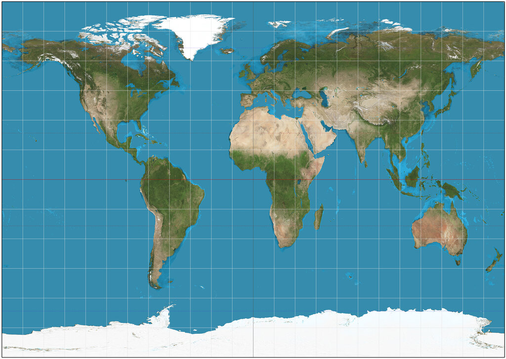
A CRS bundles together the model of the Earth's shape (the spheroid), a starting point (the datum), and the projection. Without a correctly defined CRS, your data is just floating in space. If two datasets use different CRS, they won't line up correctly, leading to significant errors in analysis and visualization.
Common Data Formats
Geospatial data is stored in specialized file formats that preserve its location information. While there are dozens of formats, a few are particularly common.
| Format | Data Type | Key Characteristics |
|---|---|---|
| Shapefile | Vector | An older, very common standard. A "shapefile" is actually a collection of multiple files that must be kept together. |
| GeoJSON | Vector | A modern, lightweight format based on JSON. It's easy for web applications to read and is human-readable. |
| GeoTIFF | Raster | A standard TIFF image file with extra geographic metadata (its CRS) embedded within it. The go-to for satellite imagery and elevation models. |
Knowing which format to use often depends on your specific needs, the software you're using, and whether you're working on the web or in a desktop environment. GeoJSON is fantastic for web maps, while Shapefiles and GeoTIFFs are workhorses in traditional Geographic Information System (GIS) software.
Ready to test your understanding? This quiz will cover the core concepts of vector and raster data, coordinate systems, and common file formats.
If you were creating a digital map of a city's public transportation system, showing individual bus routes and subway lines, which data type would be most appropriate?
What is the primary function of a Coordinate Reference System (CRS) in geospatial data?
With these fundamentals, you now have the building blocks to understand how location-based data is structured, stored, and accurately placed on a map.